Tennessee Mountain Stories

The Mystery of Manson, Tennessee

I’ve talked here a number of times about Tennessee’s ghost towns.  These boom towns that popped up around a mine or timber tract often had their own post office, railroad spur and even hotels. Sometimes their names are humorous, like Grief, Deposit or Pokeberry.  More often than not, they are named for a prominant family in the neighborhood, like Cravens, Allred or Wilder.

Then there are the mysteries. I’m writing about this one in hopes one of you knowledgeable readers can enlighten me – along with the rest of the readers. So, I will pause right here to invite you to click “comments” below and share your information.

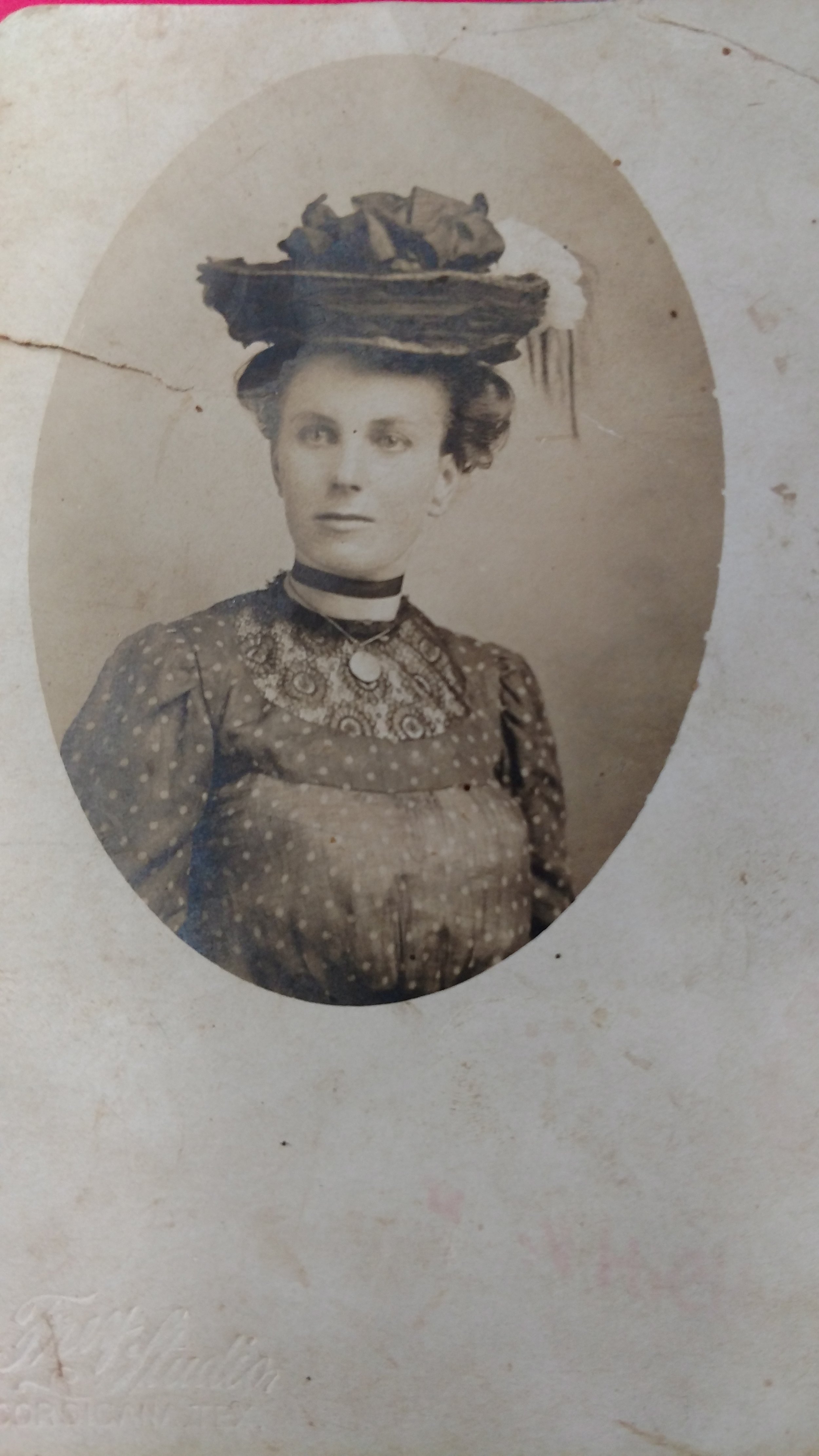
Please recall that my family was greatly blessed by a Grandmother (my Great-Great) who journaled the work, family, visits and news of the neighborhood. Her sixth oldest daughter was 48 before she married. While she stayed home to care for her invalid-mother, she nonetheless had quite the social life. And she frequently went to Manson.

I can’t help but wonder why. I took a little trip to Manson recently in hopes of finding the draw to that community. I barely found the community.

Manson never had a post office.  However, just up the mountain in Cravenstown there may have been a post office from 1907 – 1917 (at least Cravens in Overton County had service at that time). If you headed down the mountain, Boatland had a post office for a hundred years until 1955.

Most people who visit Manson today seem to travel from the Boatland direction – in fact I got some double-takes when I mentioned I wanted to take a drive from Wilder through the Manson community.  Today, the northbound, descending route is certainly the road less traveled. Yet, I find it hard to imagine in the 1940’s that many people would have driven the 25 miles to Jamestown, down the mountain to Boatland and then turned back up toward Manson…but maybe.

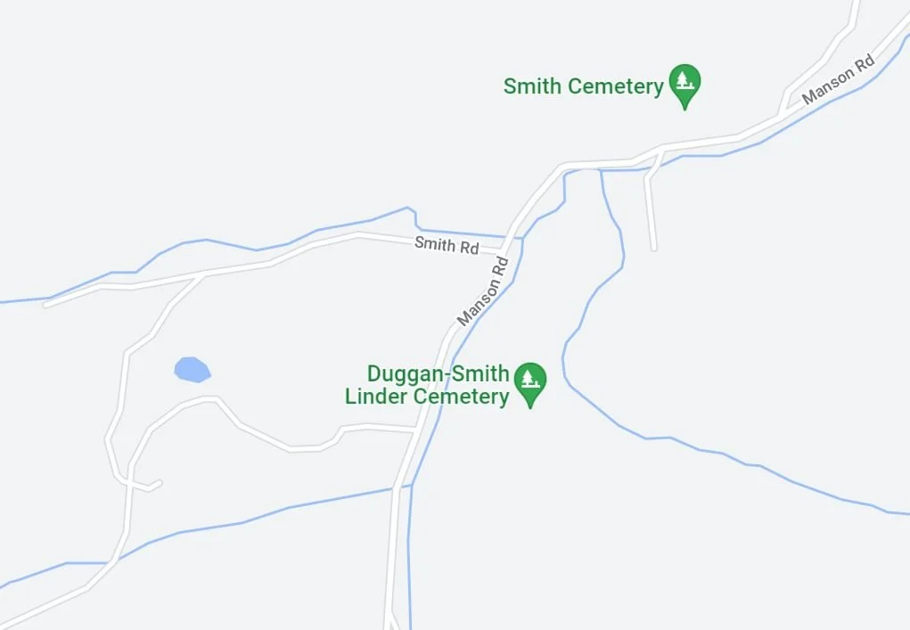
There are several cemeteries in Manson – family cemeteries – which testify to a thriving community over a period of years. Before you email me jokes that cemeteries aren’t indicators of successful communities, I want to remind you that we bury our loved ones close to us (especially in years gone by) and having people left to bury the dead is a simple sign of success.

And, there’s a church in Manson. Well, I was told there was a church. I never saw it but one of my passengers thought she saw a building that might have been a house of worship. And that was the destination my grandmother recorded.

This mountainside between Tennessee’s highway 85 and TN-52 is a rugged 15 miles as the crow flies. While there’s ample evidence of old farms, most of the cleared fields are overgrown today.  Certainly, that mountain would have held prime timber and century ago the breed of loggers in Fentress and Overton Counties would have been willing to snake the trees off of it.

On the other side of the mountain, Wilder and Davidson are best known for coal. However, a lot of timber was harvested in the same areas. While the railroad tracks provided easy transport after 1890, Manson may have yielded lumber that floated to market on the East Fork of the Obey River. Either way, a large timber operation builds quite a settlement. Yet those boom towns often had their own post offices.

There are no discernible signs of a town there now and nobody much talks about Manson anymore. Yet, my great-grandaunt saw fit to visit there; she surely had a reason.

So here you have it – more questions than answers. Yet a fascinating mystery. This is what I get as I try to peel back the layers of the personalities that inspire Tennessee Mountain Stories.

I’m looking forward to your comments!

The Rural Poor Always Manage - Somehow

A few years ago I heard a news interview with a lady from Alabama who had taken a job in Washington, D.C.  She secured lodging outside the city and talked about the poverty she saw as she drove in each morning.  One comment she made really stuck with me, and came to mind as I’ve been preparing my next book.  I can’t exactly quote her (and don’t remember her name to site that quotation anyway) but she said ‘out in the country, poor people always find a way to survive’.

On the mountain, we often consider ourselves poor people – so maybe that’s why I identified with her comment.  Yet, the more I learn about the generations who came before me, the more I realize the abundance they enjoyed.  Of course when you discuss wealth, you have to determine which ruler to use.  A scammer called me once and after I shared the gospel of Jesus Christ with him, he told me “I thought it would be okay to scam rich Americans.”  I would normally say I’m anything but rich, but I realize if my home, car, wardrobe and dinner menu were compared to the poor in Niger, Sierra Leone, or India (where that gentleman said he lived), they might just think I live like the queen of a small country.  And this is 2020.

In 1935 a cellar stocked with a good crop of potatoes, dried beans hanging from the rafters and a hog quickly fattening on fall’s acorns would’ve made most of the world envious. 

Don’t you wonder though, what did prosperity look like in 1900 or before?

In 1900 John D. Rockefeller, known as the wealthiest American of all time, would have been 61 years old and his Standard Oil Company was still intact.  The Biltmore House was just 5 years old and the industrial revolution was, well, revolutionizing America.  On Tennessee’s Cumberland Plateau, the Tennessee Central Railroad connected the Plateau to Nashville and the wide world with a line that reached to Emory Gap. 

While the railroad allowed stock and crops to be sold beyond the plateau, families here were still largely subsistence farmers.   Somehow, that term has become almost derogatory, as though survival is not enough.  In that day before you could compare whether your car was newer or faster than your neighbors, when no one had the latest iteration of cell phone or other technological gadget, wasn’t it enough to have good food on the table and healthy children?

And all of that abundance takes us right back to the land.  I think the land and the culture of those who’ve grown up close to the land is probably that ‘managing’ part of the rural poor. 

In years past, if a man could manage to get a little spot of land, he could begin building something – not just a home, but building a family and a life.  He would cut timber, work in the mines or hire himself out as farm labor until he could save enough cash money to buy a milk cow and maybe a mule to pull a plow.  He would put out a crop to feed both family and stock – and his whole family would help him. 

Sure there were cold times – homes weren’t insulated and heavy woolen coats were often a luxury.  Yet, if he worked hard cutting wood, his wife could sit close to the fireplace with the baby and they’d be okay. 

And there were hungry times as well, when crops didn’t fare well and the forest didn’t give up the game.  Yet, with a little grace (and a garden must be planted with prayer), and a lot of hard work, the land would give just about everything that family needed.  Clothing spun from cotton or wool, meat and vegetables to eat, could all be had with just a tiny amount of knowledge and a little spot of land.

It’s really no wonder that the home-place was revered.

More about The Cumberland Plateau

Here are two short articles from Harry Lane’s Tennessee Memorie

Here’s More About the Cumberland Plateau

Plateau Today.jpg

Mountains on a Plateau? That’s the situation of the Crab Orchard Mountains, which are located on the eastern side of the Cumberland Plateau…at least, that’s the situation if one considers these small peaks to be true mountains, and many would not.  Local usage, however, makes these “mountains,” and so the matter shall stand.

This section of the Cumberland Plateau is quite interesting geologically, for it represents the norther end of an up-folded part of the earth’s crust, (an anticline) that, farther south in the Sequatchie Valley area, has cracked off along the fold and moved up and over another portion of the plateau.  North of the relatively stable Crab Orchard Mountains is the enormous block of rock that is dislocated along the Pine Mountain Thrust Fault.

This district lies a few miles east of Crossville, Tennessee; the name “Crab Orchard” is well known also, as we have seen, for the building stone that is quarried in this area.  The source of the name is a village that is nestled at the base of these mountains.

The highest of these “mountains” lie about 3000 feet above sea level.  A few miles farther north, the dissected edge of the plateau itself, called the Cumberland Mountains (however confusingly!), reaches even higher, to 3534 feet at Cross Mountain, the loftiest point between the Smoky Mountains and South Dakota’s Black Hills.


The Mystery of Standing Stone

Remnant of The Standing Stone located in Monterey, TN today.

Remnant of The Standing Stone located in Monterey, TN today.

So completely has white civilization altered the environment of the Cherokee Indians within two hundred years that a place and a monument of considerable significance to Indians of the Cumberland Plateau have almost disappeared from view and from memory – the major damage having been done during the past century.  Until the coming of the railway at the turn of the century, there existed on the edge of the plateau at Monterey an Indian monument known as Nee-Yah-Kah-Tah-Kee by the Cherokees and as Standing Stone by white people of the area.  The structure was apparently reverenced by the Indians, but the railroad people evidently dynamited the Standing Stone, and only a fragment of the stone (sandstone of the Plateau Caprock) remains today – mounted at the crest of a masonry monument in Monterey in 1895 by the Improved Order of Red Men.

Mr. Lane’s artsitic rendering of the original Standing Stone

Mr. Lane’s artsitic rendering of the original Standing Stone

Much speculation, but almost no proofs, continues to be cast about as to the real nature of the Standing Stone.  Some indications are given that the monument was in the shape of an animal, perhaps a dog, but no one knows for sure.  So much for the white citizens’ concern about Indian relics during the last century!  It is also uncertain whether the monument was natural or carved.  Whether it was a natural formation or something carved by Indians long forgotten (the author prefers the natural formation explanation), it was located in a place that must have had meaning for the early travelers across the Plateau.  Apparently, the route past the Standing Stone began as a game trail that was widened by Indian and the European settlers who succeeded them, to become the Old Walton Road of the nineteenth century and eventually a motor road that leads down the escarpment to Buck Mountain, Algood, and Cookeville on the Highland Rim.  The effort needed to reach the Standing Stone by a grueling climb from the rim up the western escarpment may have led to the reverential feeling that Indians seem to have exhibited toward the monument.  Perhaps this difficult climb seemed rewarded by a view of the unusual formation or carving, whichever it was.  It is not unusual for such pilgrimages to be accomplished up steep slopes or flights of stairs to an object or place of worship.

One is reminded at this juncture of Taoist pilgrimages up 6,700 stone steps to the crest of the Tai Shan in China, the Shinto pilgrims’ climb up Mount Fujiyama of Japan, Buddhists’ upslope struggle onto Shri Pada peak in Ceylon (now Sri Lanka), the great flights of steps up the sacrificial way of the Mexican pyramids, and the 3,000 stone steps that the Judeo-Christians follow as they make pilgrimages up Mount Sinai.  In any case, the Standing Stone, before its destruction, held an imposing position overlooking the Highland Rim a few miles to the west and some 700 feet below the Plateau’s edge.


Picture Post Card

My grandmother recently shared with me a small group of pictures that came from her own grandmother.  My Great-great grandmother lived from 1886 until 1977 so these are pretty old pictures and quite a treasure.

As I looked through them I flipped each one over to see if any names or identity clues had been left.  Several of them were setup to be mailed as a post card.  One had actually been used to write a letter, although no address is included so it was clearly mailed in an envelope.  I found this little glimpse of turn-of-the-century communication to be so charming I just had to share it with you.

The note is written to Elbert and Euphemia Hixson from her sister Lizzie. I have inserted punctuation (neither period nor comma was used throughout her writing) as well as paragraph breaks in hopes it’s a little easier to read.

Dear Phemie & Elbert,

We have been looking for a letter from you ever so long, are still expecting you all up here this fall.  I am thinking of visiting Tennessee next summer if I don’t change my mind. 

I believe we’ve had the driest time I ever saw.  My well gets low when I wash but soon fills up again.  Sure have fine water and I have my winter stove wood already up too.  That is a great relief. 

Write soon.

Lizzie Hixson


IMG_20170811_113754422.jpg

There you have it.  Less than 250 words written to a sister she had not heard from.  In that she manages to share travel plans, weather report and winter preparations.  She doesn’t explain the picture on the post card – maybe this was her usual writing stock and her sister would not have wondered about the image.  With both greeting and salutation on the card, I wouldn’t expect there was anything else in the envelope. 

Don’t you just wish you could ask her a whole bunch of questions after reading this?  I sure do. 


Country Roads

Ah, the thought of a country road conjures movie scenes, old tales and song lyrics galore. 

Now I didn’t grow up on a dirt road – in fact they’re pretty hard to find these days.  Nor do my children play in a dusty path, but you couldn’t convince them that they are missing anything as they pick through gravels and find even the tiniest depression that holds water for splashing little shoes.  A trip to the mailbox is full of adventure and watching them again brings to mind fanciful memories.

A couple of weeks ago I included a picture of Ernest Hall standing no doubt along the path to his father’s  Roslin, Tennessee farm with a split rail fence on one side and a barn on the other side.  He’s probably in his early twenties but the joy in his smile makes you think that the hard work on that farm has not begun to dim his spirit.

So many of the stories I’ve heard all my life include walks along the Plateau’s country roads.  I recently drove from I-40’s Plateau Road exit across to Hwy 62.  The first novel I wrote (and have yet to release but I promise I’ll get it out one day) was largely set in the Elmore Community along Clear Creek Road.  Two characters in the book needed to travel toward that Plateau exit and I sent them along the Keye’s Road.  Today that road is a very narrow two-lane roughly paved road.  It’s bordered by over-arching trees, fence rows and homes.  I couldn’t help but imagine walking along it in the early morning hours at the beginning of a long journey.  Of course, in those no-fence-law days so many people took the nigh-way that well-worn paths crisscrossed the mountain.  We mainly have to stick to the roads these days but it’s still fun to think of the quiet of those days without motorcars.  It challenges me to think of the distances my forefathers traveled on foot.  And it thrills me that I have enough stories that I can begin to picture their steps along these same routes.

Hmm, now that I think of it country roads are almost as much fun for me as they are for my children.