Tennessee Mountain Stories

The Coves of East Tennessee and Gold in Coker Creek

We’ve talked here before about Gold in Tennessee - but Mr. Lane’s work revealed a new location for me - there’s just no telin’ what’s in our moutains!

Coves.jpg

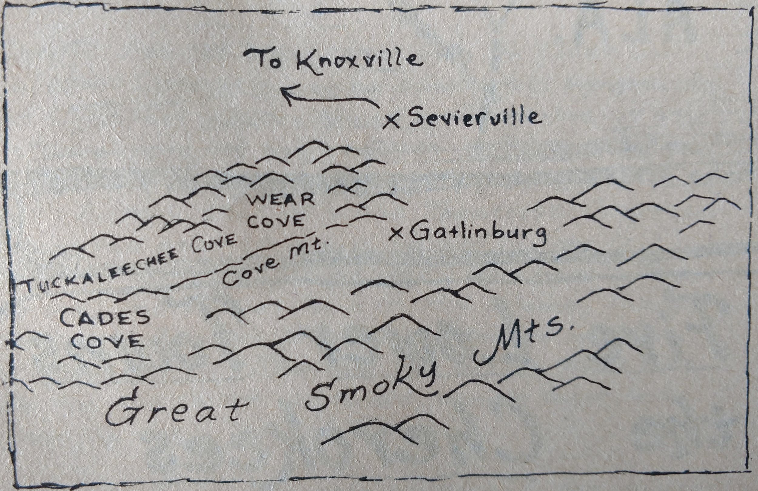
The northwest side of the Smoky Mountains of Tennessee displays the features known as coves.  These are basins on that side of the mountains that have resulted from special geological circumstances.  Here, old faults (cracks in the earth’s crust, with movement along the cracks) onto rocks of younger age.  The total overthrust movement was as much as 35 miles.  Erosion has since broken through the older, overlying crystalline rocks to expose the younger limestones beneath.  The limestone has, upon being weathered, produced good soil that has made possible a productive agriculture in the coves.  Geologist call this type of cove a “fenster”, the German word for window; the holes eroded in the overlying rocks provide just that – a “window” through which the lower rocks may be viewed.

The best known of the coves of the Smokies is Cades Cove, in Blount County, a spot of rare beauty.  Cades Cove is accessible to tourists.  It is of special interest not only for its beauty, but also because of the preservation there of farmsteads as they appeared in bygone days, together with the traditional tools and agricultural practices.  Other coves of the Smokies include Wear, Bumpass, and Tuckaleechee.

At Coker Creek in the Blue Ridge of southeastern Tennessee, gold mining was once significant enough that there was a “rush” of sorts to the area in the first half of the nineteenth century  Discovery of gold occurred there in 1827; commercial mining only lasted four years, however, from 1856 – 1860

The gold mined from Coker Creek was found largely by the “placer” or washing method.  The amount of gold mined here was not large, total production amounting to only a quarter-million dollars or so – and the relatively “lean” ore never brought riches to the miners, as did the discoveries in California and some other area.  Still, this episode makes an interesting “byway” in the path of Tennessee history.  Gold excites the imagination, and even today, amateur prospectors may be found from time to time, panning in Coker Creek for the thrill of “color” – the brilliant golden flash that quickens the pulse, no matter how small the amount and value of the flakes.  Coker Creek is located in the southeastern end of Monroe County.  It is north of Ironsburg and southeast of Tellico Plains.

Part 2 of Those Wild Tennessee Place Names

From Harry Lane’s Tennessee Memories, this article is lengthy so I’m only sharing excerpts and have broken those into 2 weeks.

The tools of everyday life are honored in Tennessee place names.  The Sawteeth, ridges in The Great Smokies of Sevier County, are an example.  Tilthammer Shoals in Sullivan County recalls the heavy drop hammers of the many forges that once were numerous on the landscape.  …Whetstone Mountain in Morgan County and Grindstone Hollow in Coffee County recall the times, not long past, when virtually everyone sharpened his own knives and other tools.  Slabtown Branch in Johnson County brings to mind sawmill villages that once were found in the state, as does Sawblade Road in Cheatham County.

Sometimes, Tennessee place names commemorate hard and unpleasant times.  Difficult and Defeated in Smith County certainly indicate as much, as does Troublesome Hollow in Sullivan County.  So, too do these:  Poorhouse Branch in Robertson County; Dismal Gap in Anderson County; Penitentiary Gulf in Bledsoe County; …Calfkiller River in Putnam and White Counties; …No Pone Ridge in Meigs County and Burnt Pone Creek in Campbell County; Starve Pond in Lake County.

Even names of cemeteries in Tennessee are at times quite amusing, whether accidentally or by intent.  An example is Faint Hope Cemetery in Hardin County; others are Ruffian Cemetery in Hardeman County; Coward Cemetery (and who is not, about being “planted there!), in Hawkins County; Scratchunder Cemetery in Haywood County, Hotwater Cemetery in Hamilton County; Poor House Cemetery in Warren County…Moulden (Mouldin’?) Cemetery in Knox County;…Humble Cemetery in Bledsoe County; …Not to mention Freewill (whose?!!) Cemetery in Lake County!

View Tree Knob.jpg

 A sense of mystery and superstition ore observable in some place names:  Booger Hill and Booger Swamp in Jackson and Putnam Counties, respectively; Hoodoo Community in Coffee County; The Deadening and Black Drowning Creek in Cumberland County; Dark Hollow and Haunted Hollow in Johnson County; Scary Hollow and Hall Deadening Hollow in Perry County.  A number of places’ names indicate things devilish – old Beelzebub himself, or his fiery place of destruction:  Devil’s Backbone (Marshall County and Cocke County); Devil’s Kitchen Branch and Devil’s Elbow in Greene County (the latter also in Smith County); Devil’s Nose Mountain (Hawkins County); Hell Hole (White County); Devil’s Looking Glass (Unicoi County)…

The pleased palate is remembered in the names of numerous locations:  Fattynbread Branch and Pumpkin Avenue (Dickson County); Hushpuppy Lake (Dyer County): Yum Yum Community (Fayette County); Sorghum Patch Hollow and Sugartime Springs (Franklin County); Slay Bacon Area (Sevier County – we thought all bacon had been “pre-slain”!); Onionbed Ridge (Sullivan County); …Poke Patch Creek (Cumberland County); Buttermilk Road and Cabbage Island (Knox County); …Okra Community and Tater Hill (Pickett County); and Lickskillet Branch (Hawkins County).

In which of these Tennessee streams would you prefer to swim:  Ebbing and Flowing Spring or Washboard Creek (Hawkins County); Greasy Creek (Henderson County): Scarce Grease Branch (Grundy County), or Big Fiery Gizzard Creek (Grundy County)?  Or perhaps Briarpatch Lake (Henry County)?

Among the more memorable names in the states are several given in honor of old ladies in families, or other relatives.  These include Granny White Pike (Davidson County); Aunt Sal Hollow (Jackson County); Grandma Hollow and Grandaddy Hill (Campbell County); Mammy’s Creek and Daddy’s Creek (Cumberland County); Aunt Lude Ridge (Lewis County); Granny Branch (Benton County); Aunt Jane Hollow (Hamblen County); Daddy Ridge (Overton County); and Granny Scot Hollow (Wayne County).

…A considerable number of Tennessee names may be attributed simply to humorous imaginations.  Spankem Branch (Moore County); Bona Factus Branch (Morgan County): Screamer Community and She Boss Church (Maury  County); Black Ankle Creek (Meigs County); Jackass Hollow (Montgomery County); Pulltight Hollow (Hamilton County); Bucksnort Community (Hickman and Gibson Counties); Ugly Hollow (Greene County); Squeeze Up Bluff (Wayne County); Henpeck Lane (Williamson County)_; Wild Bill Road (Wilson County); Graball Community and Doodle Hollow (Sumner County); Random Shot Landing (Tipton County);l…Wallop Hollow (Union County); Fuss Hollow and Bugtussle Hollow (Lincoln County); Scratch Ankle Hollow (Marion County); …Big He Creek (Sequatchie County); Steep Gut Hollow (Claiborne Country); …Shakerag Hollow, Falling Over Branch, and Pinchgut Hollow (Jackson County); Rotten Fork School (Fentress County); How Come You Creek (Cumberland County).  And yes, folks, there really is a Grinders Switch in Hickman County, as Minnie Pearl has so often indicated  and – a Hootin Hollow (“Holler”) in Bradley County!

Sugar Loaf.jpg

Those Wild Tennessee Place Names!

Part 1

From Harry Lane’s Tennessee Memories, this article is lengthy so I’m sharing excerpts this week and next.

All of the artwork in Tennessee Memories are original creations by Mr. Harry Lane.

All of the artwork in Tennessee Memories are original creations by Mr. Harry Lane.

A careful look through a volume of place-names that actually appear on Tennessee maps, reals a large number of names that are fascinating, for various reason:  some are very beautiful, many are hilarious, others are puzzling, still others reveal something significant in the history of the state.  Many of the place names discussed in this article produce this in common – a sense of wonder in the author as to how they came to be used.  Probably most of these, and other place names, “sort of happen.”  Someone with a sense of humor refers to a place by an amusing name, and it catches on.  Someone else with an appreciation of history, or of things esthetic, etc., might give a very different sort of name to the same place.  In this more or less accidental manner, as in so much of human experience, place names come to be used for generation.  Now and again one is changed, and it is perhaps mysterious that this doesn’t happen more often – especially when a name is unattractive or even derogatory to those who live there.  People are creatures of habit, and possibly have a better wit than might be thought s- even to the point of finding “far out” names for their own dwelling places…

If your taste runs primarily to things serious and beautiful, esthetically unimpeachable perhaps, then there is much to please you in Tennessee place names.  To wit: Bluebird Ridge in Anderson County, Bluewind Community in Cannon County,…Birdsong Greek in Benton County,… Cerulean Knob in Blount County, Periwinkle Spring and Lavender Knob in Cumberland  County.  Other names of beauty include:  …Lovely Spring Branch (Fentress County);...

Still other names that indicate pleasant memories are: Summer Shade Church and Happy Hollow (Overton County); …View Tree Knob (Scott County); Painters Knob  and Rainbow Falls (Sevier County); Feather Ridge (Sullivan County); Lindamood Hollow (Union County); Honeysuckle Lane (Trousdale County).

For those who treasure the excitement and romance of adventures here and in faraway places (and who does not?), these Tennessee place names should appeal: Lebanon; Sparta; Athens; Egypt; Carthage; Paris; Bordeaux; Moscow; Belfast; Bogata; Monterey; Cuba; India. The historical side of an area’s settlement is nearly always suggested by its name, of course, in one way or another, but in some names the “winds of history” blow more strongly than in others.  The history suggested may be of local interest only, but the fascination such names may hold is not diminished by this condition – for instance, Bark Legging Lead is a spot in Polk County that implies much about the days of the Cherokees and white frontiersmen in the county.

Sevier County has several places whose names suggest the days of Indian dangers to white settlers. (The reverse danger does not enter the place name situation, since the whites were the victors!)  Fighting Creek Gap, Fort Harry (point), Hostility Branch, and Tomahawk Prong are the best of these.

There are many place names of strictly Indian origin, so it is evident that the white settlers did not hold their Native American adversaries in such contempt as to remove their every stamp of identity from the land.  (In this regard, it is also worth noting that a great many American whites claim with pride to have Indian ancestors.)  Among the many Indian names that dot the Tennessee landscape is the name of the state itself, and others like these:  Chattanooga, Ocoee; Hatchie; Tuckaleechee; Sequatchie; Hiawassee; Etowah; Sewanee; Watauga; Tellico; Chilhowee; Chickamauga; Nolichucky; Mississippi; Loosahatchie; Chickasaw; and Cherokee.

Burnt House Spring in Scott County may recall a time when the Indian-white conflict troubled the area, but in any case, the event of the burning must have been prominent in people’s minds to result in the place name.  ON a lighter note, Ball Play community in Polk County records in its name a pastime that undoubtedly brought pleasure to many of the area’s inhabitants – and may do so yet.

…These also indicate our agricultural background…Wheatbread Hollow (Hawkins County); Bellcow Mountain (Greene County); …and Brown Mare Branch (Sevier County)

Cumberland: What’s in a Name?

From Harry Lane’s Tennessee Memories

Prince William, Duke of Cumberland

Prince William, Duke of Cumberland

Today’s excerpt from Mr. Lane’s writings is short but he touches on a term we routinely use, calling our plateau home “the mountain”, so I wanted to be sure to include it.  I’d love to hear your comments below.

The origin of this name lies in England; the name was first applied in Tennessee when a section of what is now the Cumberland Plateau was name the Cumberland Mountains in honor of the Duke of Cumberland.

Ambiguity has arisen across the years and has continued in the application of the name.  The name Cumberland Plateau is applied to the southern section of the Appalachian Plateaus, from Kentucky through Tennessee and into northern Alabama.  The section of the Appalachian Plateaus in West Virginia, eastern Ohio, Pennsylvania, and southern New York is called the Allegheny Plateau.

On the other hand, there is a very rough, irregular, high section of the Cumberland Plateau – the original part of which the name was first applied – that is still known as the Cumberland Mountain.  Making things a big more confusing is the fact that many Highland Rim citizens refer to any part of the plateau as “the mountain.”  “Up on the mountain” is a commonplace expression on the Rim.

The Cumberland River flows across the Plateau in Kentucky and Tennessee leaving the plateau to cross the Highland Rim and the Central (Nashville) Basin, finally flowing back across Kentucky and entering the Ohio River not far from the mouth of the Tennessee River.  The river mouth is distant from the territory originally called Cumberland.

Tennessee Folklore in Weather Prediction

From Harry Lane’s Tennessee Memories

Among the interesting humor stories associated with weather in this area is the folklore of weather prediction.  There seem to be uncommonly many weather prognosticators in the Cumberland Plateau area, of whom the best known may be Mrs. Hellen Lane of Crab Orchard.  Many observers might readily ascribe this lore to ignorance and superstition, but there is little doubt that some folk wisom is derived from keen observation of nature.  Perhaps the long-range prognostication is not god, but it has been shown that close study of nature can often produce short-term weather forecasts with reasonable accuracy.  For example, there is an old belief that when Lookout Mountain (a continuation of Walden Ridge, part of the Cumberland Plateau) “has its’ cap on,” it will rain in about six hours.  Experience has shown that when the sky “lowers,” that is, when the cloud ceiling decreases, rain commonly follows in a short time; so this piece of folk wisdom is a reasonable prediction.

Another example of weather-forecast wisdom sometimes set forth by Tennessee prognosticators is that swallows and bats will fly closer to the ground before a rain.  This seems to be true, since these birds (and mammals, as bats are!) have sensitive inner-ear mechanisms, and a sudden drop in air pressure preceding a rain may cause them to seek the somewhat higher pressure that is found near ground level.

Still another piece of weather lore that has validity is the saying that when katydids say “Kate,” they announce the nearness of frost.  It has been demonstrated that the katydid call slackens from “Kate-ee-did-n’t” at 87° F to “Kate” at 58°F, to muteness at 55°F or below.  It follows that the gradual cooling of air in autumn will eventually silence these insects as frost approaches.  The same thing is true of the chirps of crickets.

As for the presumed associations between other natural phenomena and weather events, the writer can claim no proofs for the accuracy of studies involving wooly worms, spider webs, the number of fogs in August, and many other such “keys!” Society would be poorer, however, without such colorful weather folklore.